|
Highlights / Points of Interest:
The Layered Forest
Evergreens and fewer hardwoods; Spruces and cedars that
dominate the moist forests. The "herb layer", dominated
by plants and wild flowers such as maple
seedlings, trilliums, solomon's seal, ferns,
and other low growing plants. Birds like
the Ovenbird live on or near the ground
among plants this size. The canopy
layer, typically made up of beech, maple
and yellow birch trees.
Watch and listen for birds such as the
spectacular Scarlet Tanager. The "understorey", made up of saplings of
the big canopy trees, as well as a number
of different shrubs and small types of
trees such as ironwood. A number of
birds live in this middle layer. One of
these is a tiny orange and black warbler
called the American Redstart. This bird
spends its winters in the forests of South
America.
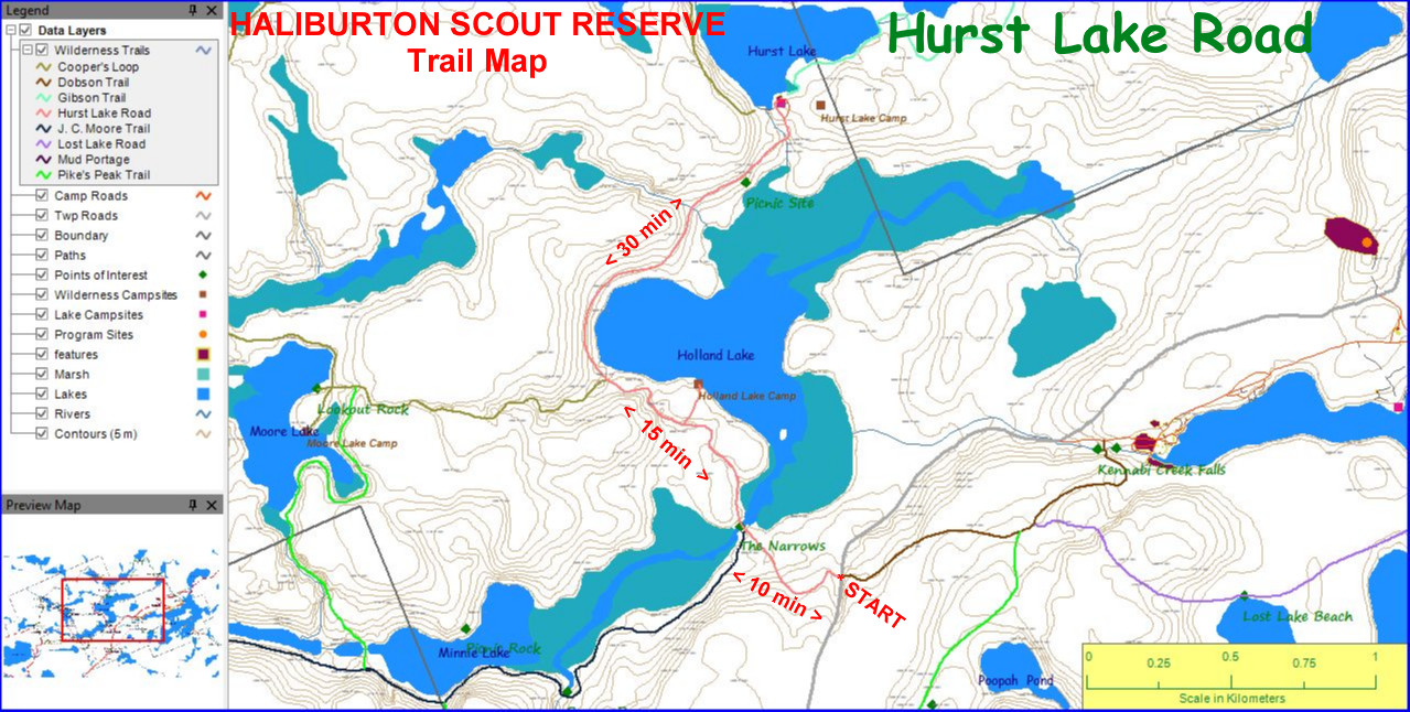
The Narrows:
A
slow moving creek joining Minnie Lake to
the west with Holland Lake to the north
east, surrounded by wetlands.
What Can You Find in a Wetland?
Wildflowers, Shrubs, Everygreens, Spring Peepers, Bullfrogs, Great Blue Herons, Osprey.
Camp 5A of the Laking Lumber Company
Hurst Pavalion and Campsites
Holland Lake Campsite.
 |
Average Hiking Time (Distance):
From Hurst Lake Gates on Kennaway Rd.:
• to JC Trail/Narrows - 10 minutes (0.4
km or 0.25 mi);
• to Cooper's Loop Trailhead (South) -
25 minutes (1.1 km or 0.68 mi);
• to Hurst Lake Pavilion, Gibson Trailhead & Cooper's
Loop Trailhead (North) - 55 minutes
(2.4 km or 1.49 mi).
|
|
Descriptions & Directions:
This trail follows along the Hurst Lake
Road, which is a private road used by the
camp for maintenance and emergency
access. The road, like the lake, was
named after Fredrick C. Hurst, first Haliburton Camp Committee Chairman.
There are no trail markers along this road
but you won't have any trouble finding
your way. Junctions with the JC, Cooper's
Loop and Gibson Trails are all clearly
marked with signs and trail markers.
From the north side of Kennaway Road, the camp road / trail winds
through a deciduous forest
composed mainly of sugar maple, yellow
birch and a few beeches. After about one
half kilometre, the trail opens up onto a
slow moving creek joining Minnie Lake to
the west with Holland Lake to the north
east. On the left, just before the road
starts down to this creek is the start of the
JC Trail, which leads to
Minnie Lake, the foot of Pikes Peak and
eventually to Drag Lake. This creek is a
typical low energy creek, much altered
over time by the work of beavers, that can
be found throughout the Canadian Shield.
These wide, marshy areas, known as wet-lands, are full of different kinds of plants
and animals and are very valuable for
wildlife.
What Can You Find in a Wetland? - The
creek slowly winds its way through a wide
mat of grasses, sedges and bulrushes.
Here and there, you might be able to spot
the odd wild flower, such as the deep
blue flowers of Pickerel Weed (which
flowers in August) or yellow and white
water lilies out in shallow water, or Blue
Flag (which flowers in June) along the
edge. Where the land gets a bit higher at
the edge of the stream, shrubs like Sweet
Gale (the crushed leaves smell sweet)
and Speckled Alder have taken root. A
little higher still, behind the marshy areas,
evergreens such as white cedar and
white spruce form the boundary between
the stream bed and the forest.
If you are lucky enough to be here when
the frogs are calling, listen for loud peeps
of the spring peepers, or the booming "jug-o-rum" of the bullfrog. Watch for
Great Blue Herons stalking the shallows
for fish and frogs, and keep your eyes
open for Osprey, which only eat fish, as
they fly over the creek.
As we leave the creek, to the beginning of
the Moore Lake Road (The CL Trail), the
trail goes through two types of forest.
Where the ground is a bit lower, it is also
wetter, and moist areas tend to have
more evergreens and fewer hardwoods.
Watch for the spruces and cedars that
dominate these moist forests.
The Layered Forest - The other type of
forest, on higher ground, is our old friend
the maple forest. One of the characteristics of this type of forest is its tendency to
form distinct layers. Along the ground is
what is called the "herb layer", dominated
by plants and wild flowers such as maple
seedlings, trilliums, solomon's seal, ferns,
and other low growing plants. Birds like
the Ovenbird live on or near the ground
among plants this size.
At the very top of the forest is the canopy
layer, typically made up of beech, maple
and yellow birch trees in this forest.
Watch and listen for birds such as the
spectacular Scarlet Tanager, which can
be found making their living high up in the
canopy.
In between the top and bottom layers is
the understorey, made up of saplings of
the big canopy trees, as well as a number
of different shrubs and small types of
trees such as ironwood. A number of
birds live in this middle layer. One of
these is a tiny orange and black warbler
called the American Redstart, which the
South American Indians call "the candles
of the forest". Like many other birds we
see in our forests in the summer, this bird
spends its winters in the forests of South
America, away from the cold and snow of
the long Ontario winters. If only we could
all be so lucky!
About 500 metres from the Narrows, a
short trail to the right leads to the Holland
Lake campsite.
After another 50 metres,
the Cooper's Loop Trail to Moore and
Mislaid Lakes, starts on your left.
The Hurst Lake Road continues
to wind around Holland Lake to the right
and then back to the left to Hurst Lake.
On your left rise some striking rock cliffs
set about 75 metres (243 ft) back from
the road. Beyond Holland Lake, you will
pass through a sandy open area where
camp 5A of the Laking Lumber Company
was once located. More recently it is used
as a gravel pit to maintain the road. You
will cross two streams along the road, the
second of which has a bridge and is know
as the "River Cry". It flows down through
a maze of boulders from Hurst Lake and
means you're almost there! The road now
curves up and to the left where it forks
(both routes meet at the top) and when
you reach the high ground, you'll be at
the main Hurst Lake camp site and shelter located on a pine-covered rock over-
looking the lake.
Down and to the right leads to another
fine campsite on the point and to the Gibson Trail.
Down and to the
left (and back across the "River Cry") is
the northern trailhead for the Cooper's
Loop Trail.
|

 (Custom).JPG)
 (2).jpg)
.jpg)